.
The Alcohol and Tobacco Tax and Trade and Tax Bureau (TTB) of the United States has approved a new American Viticultural Area (AVA), to be known as the Van Duzer Corridor AVA. The new AVA—covering approximately 59,871 acres in portions of Polk and Yamhill Counties in Oregon—lies directly to the west of (and along the western border of) the Eola-Amity Hills AVA, and is entirely within the boundaries of established Willamette Valley AVA. This brings the total number of AVAs in the US to 244, and a total of 19 in Oregon.
The Van Duzer Corridor AVA will be in effect as of January 14, 2019. According to the TTB’s statement, there are 18 commercially-producing vineyards covering a total of approximately 1,000 acres of vines and 6 wineries—including Van Duzer Vineyards, Firesteed Winery, and Left Coast Cellars—located within the boundaries of the new AVA.
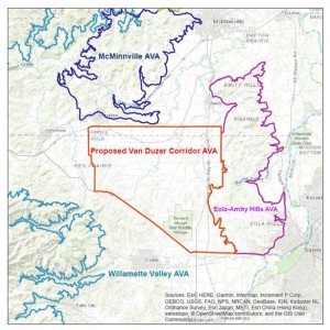
Map of the Van Duzer Corridor AVA, via the original petition (TTB website)
The AVA petition acknowledges that the area within the Van Duzer Corridor shares many features with the surrounding areas; however, the region is sufficiently unique to have been established as a separate AVA…particularly due to its winds. The distinguishing features of the area include the following:
- The elevation: The Van Duzer Corridor itself is a narrow tunnel-like “wind gap” (area of low elevation) tucked into the Coastal Ranges. Commercial vineyards in the area are planted at an elevations ranging from 150 feet to 650 feet above sea level. The areas located to the north, south, and west of the Van Duzer Corridor AVA are far more mountainous, with elevations ranging from 600 feet to 2,000 feet above sea level.
- The winds: The new AVA is located at the eastern edge of this wind gap where the tunnel-like area of low elevation expands into a wide region of rolling hills that allow the cool, eastward-flowing marine air to flow relatively unimpeded. According to the petition, the average daily wine speed in the Van Duzer Corridor AVA is approximately 10 miles per hour—nearly twice the average speed of the surrounding areas.
- The climate: The average temperature of the Van Duzer Corridor AVA is consistently cooler than the surrounding areas. The Van Duzer Corridor area averages several hundred cumulative degree days fewer than the surrounding areas during the growing season. For instance, in 2014, the McMinnville AVA had a total of 2819 growing degree days (GDD), while the Van Duzer Corridor had 2624 GGD. This lower overall temperature leads to a longer growing season, longer “hangtime,” and—combined with the effects of the wind—thicker-skinned grapes.
Fun Fact: the original petition, filed by Jeff Havlin—chairman of the Van Duzer Corridor AVA Committee and owner of Havlin Vineyard—in 2011, listed the AVA’s name as “Perrydale Hills.” However, the TTB determined that the suggested name did not have sufficient national recognition (“viticultural significance”) and the name was eventually changed to Van Duzer Corridor.
Welcome to the world, Van Duzer Corridor AVA!
References/for more information:
- TTB’s Notice of Proposed Rulemaking regarding the Van Duzer Corridor AVA
- Open Docket Folder for the Van Duzer Corridor AVA
- Van Duzer Corridor AVA Petition
- http://www.oregonwinepress.com/a-real-van-doozy
- SWE’s updated map of the Willamette Valley
Do you have a link to the original map file?
I do not – however, several maps are available on the TTB’s open docket.