The Ancestor Vines of Barossa

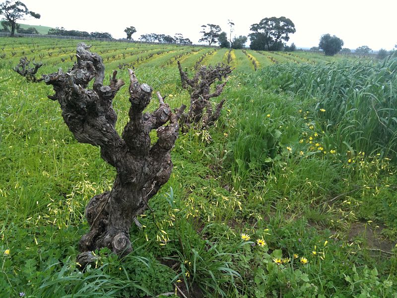
Photo by Stephan Ridgway

Photo by Stephan Ridgway

Old vines…for many of us, the term “old vine” implies that a wine is produced from grapes grown on a grapevine of more than 20, or 50, or 100 years of age (the exact number depending on where exactly the vineyard is and your point of view). In addition, we believe that their fruit, having been painstakingly ripened by a grizzled old vine, will be exceptionally rich, concentrated, and complex.

While I am sure most wine aficionados would agree with that purposefully vague description, the truth remains that “old vine” (or vieilles vignes, as the French say) remains a largely unregulated and undefined wine term. After all, a lot depends on context. If you grow grapes in Châteauneuf-du-Pape or Jerez, the idea of “old” might actually start at about the half-century mark. On the other hand, if you grow grapes in the Canterbury Plains or Elkton, Oregon, you might start to think of your vines as “old timers” once the hit 20 years old.

One thing that just about everyone can agree upon, however, is that the older vines of the world need to be protected, respected, and – in the best of all possible worlds – documented and substantiated. To this end, Barossa Australia—formerly the Barossa Grape and Wine Association—which has over 500 grape growers and claims to have more old vines than any other region in the world, has taken steps to do so. After all, as Ron “The Dirtman” Gibson, of Gibson Wines in the Barossa says, “Old vines aren’t good because they’re old, they’re old because they are good.”
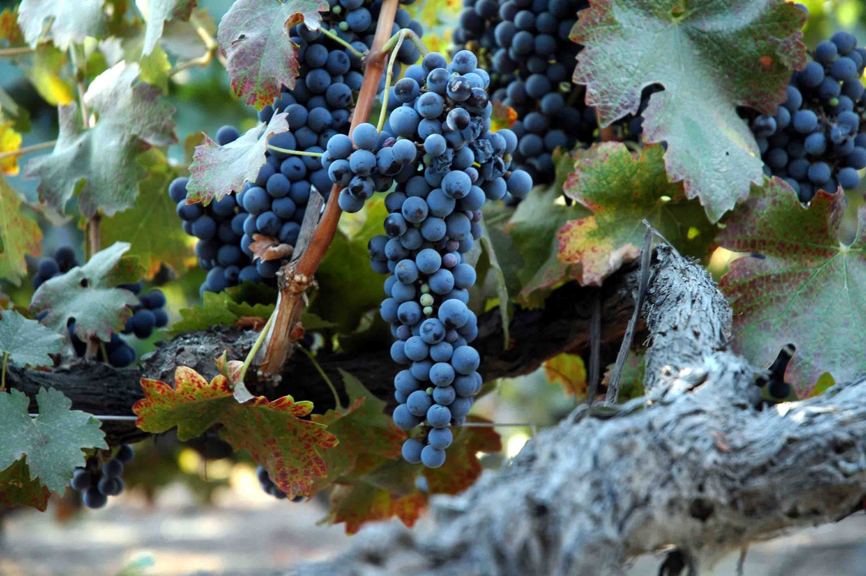
Photo by Verita Photography

Photo by Verita Photography

The organization has released what might be the only specific definition of the term “old vine” in the wine-making world. Although these terms are not regulated by the Australian Government—nor are they approved as official wine descriptors—this is at least a good first step in understanding and honoring the area’s old vines.

The classifications of Barossa’s old vines are as follows:

  • Old Vines: 35 years old or over
  • Survivor Vines: 70 years old or over
  • Centenarian Vines: 100 years old or over
  • Ancestor Vines: 125 years old or over

Barossa Australia has also published the “Barossa Old Vine Charter,” a declaration of sorts intended to protect and recognize the region’s oldest vines, some of which date back to 1909 or earlier and are to be considered part of Australia’s living history. The organization also keeps a Barossa Vineyards Register, which details the vineyards of the area by grape variety and by age.  The Barossa Vineyards Register, and the Barossa Old Vine Charter can be found on the website of Barossa Australia.

Post authored by Jane A. Nickles, CSS, CWE – your SWE Blog Administrator

References/for more information:
Click here to return to the SWE Homepage.

Dispatch from the León DO

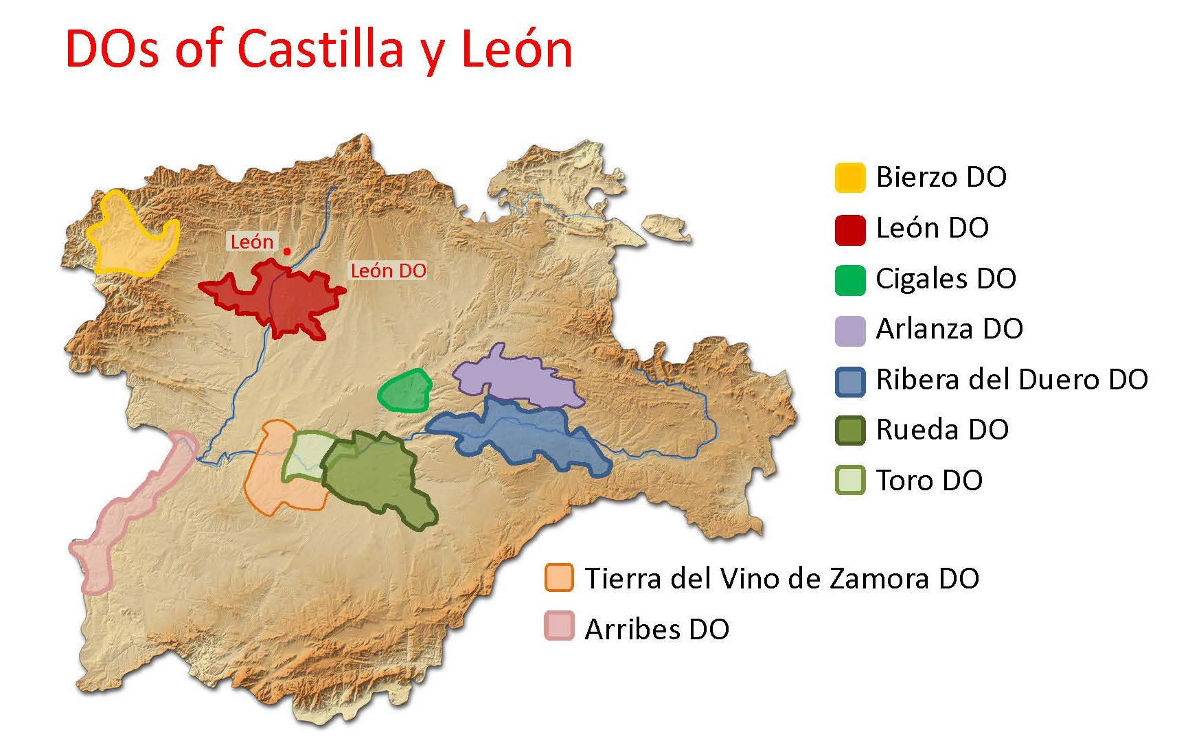
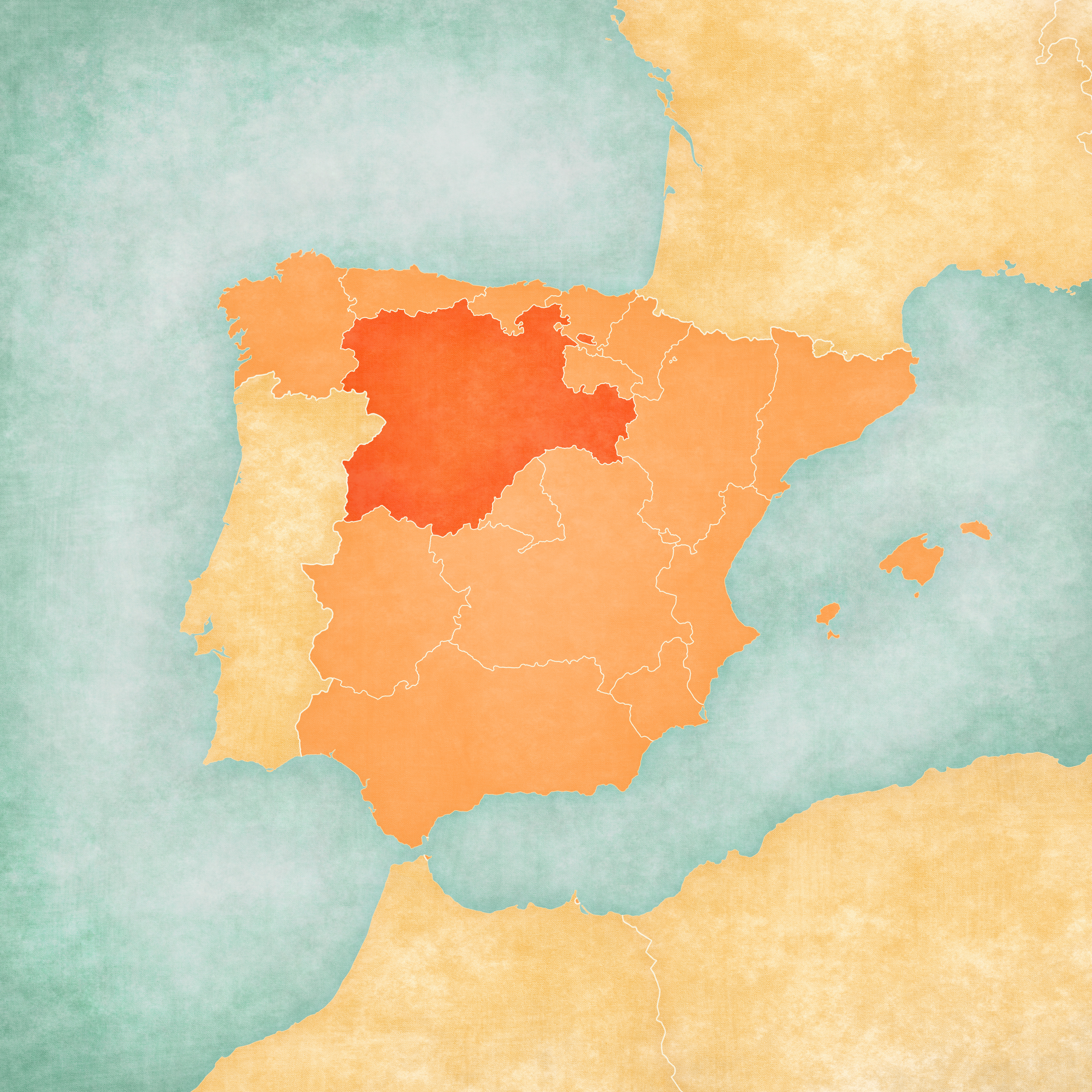
Map of Iberian Peninsula - Castile and LeonAttention, wine students! The Tierra de León DO (approved in 2007) has changed its name; the new name is: León DO.

The León DO is located along the Esla River, just a few miles (km) south of the city of León. It is perched atop the high plateau—the Meseta Central—that covers much of central Spain and as such, its vineyards are located at an average of 2,650 feet (800 m) above sea level.

The León DO is largely red wine country; more than 90% of its vines are planted to red grapes. The leading grape variety—accounting for nearly 70% of the region’s 4,100 acres (1,660 ha) of vines—is Prieto Picudo, typically the majority variety in the areas rich-and-fruity red wines (as well as a small showing of rosé).

Prieto Picudo is thought to be native to the area just south of the city of León and is found almost exclusively in Castilla y León. The vine tends to produce small bunches of compact grapes with somewhat thin skins. The wines produced using Prieto Picudo are known for their cherry-red hue, high aromatics (including cherry, red berry, black pepper, and forest floor) as well as a good zing of acidity and alcohol.

wine Map castilla y leonThe remainder of the of the (red grape) vineyards are planted to Tempranillo (occupying 17% of the area), Mencía (4%) and Garnacha Tinta (less than 1%). The tinta (red wines) of León are required to be made using a minimum of 60% (combined) Preito Picudo and/or Menía—a nod to these unique grapes considered to be native to the area. The remainder of the blend (up to a maximum [combined] of 40%) may be comprised of the accessory varieties—Tempranillo and Garnacha Tinta.

The León DO also produces a small amount of white wine; just under 10% of the area’s vineyards are planted to white grapes. Wine students will be interested to know that the regulations concerning the area’s white wines were recently updated, and that the current laws allow for just three white grapes— Verdejo, Albarín Blanco and Godello—to be so used. (Palomino and Malvasia are no longer allowed, as of the 2020 vintage).

References/for more information:
Post authored by Jane A. Nickles…your blog administrator: jnickles@societyofwineeducators.org

The Rise of Ramato: Dispatch from the delle Venezie DOC

Logo of the delle Venezie DOC via: https://dellevenezie.it/en/

Logo of the delle Venezie DOC via: https://dellevenezie.it/en/

Dispatch from the delle Venezie DOC! The Disciplinare di Produzione for the delle Venezie DOC has been updated to allow for the production of rosato (rosé) and ramato styles of wine based on the Pinot Grigio grape.

As you may have guessed, there is a bit more to the story!

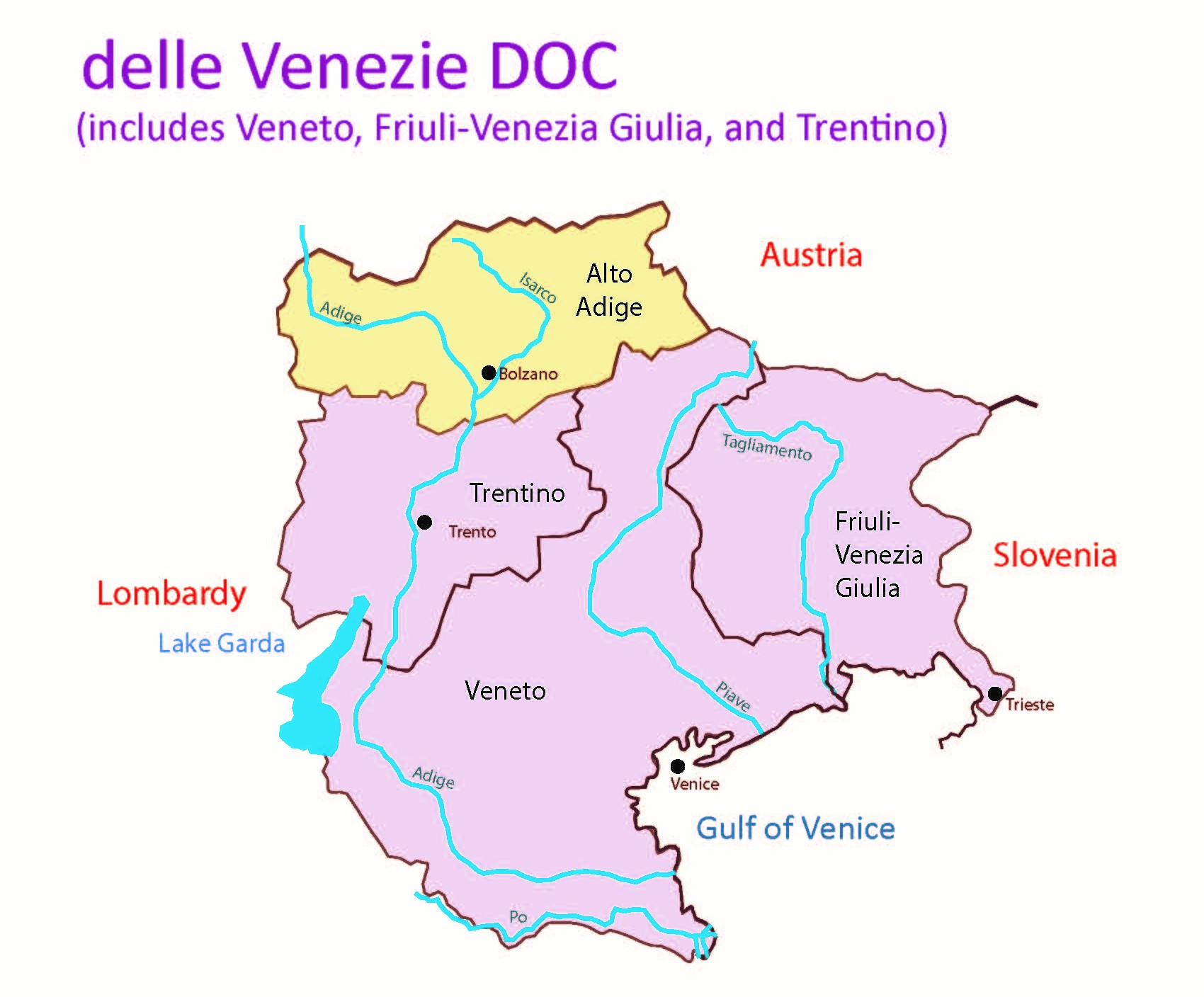
Winemakers in the northeast of Italy (namely Friuli-Venezia Giulia. Veneto, and the Trentino-Alto Adige) have successfully grown Pinot Grigio—brought to the region via France where it is known as Pinot Gris—for hundreds of years.

The area’s Pinot Grigio is typically produced as a dry, crisp, easy-to-love and fruity white wine with a light yellow(ish) color. This style of wine is enormously popular; so much so that a multi-regional DOC area—the delle Venezie DOC—was created in 2017 to grant these delightful wines a bit of the respect they deserve and allow varietally-labeled Pinot Grigio from Veneto Region, Friuli-Venezia Giulia Region, and the Trentino Province to wear the DOC label. (Sparkling Pinot Grigio and white wine blends—bianco—based around Pinot Grigio, Chardonnay, Pinot Bianco, Muller Thurgau, Garganega, Verduzzo, and/or Tocai Friulano are also approved for production under the delle Venezie DOC.)

.

.

Despite the popularity of the fresh-and-fruity style of Pinot Grigio, winemakers in Italy’s northeast have traditionally spun Pinot Grigio into other styles of wine as well. A light pink rosato/rosé is created by allowing the juice (post-crush) to macerate alongside the skins of the grey/pink hued grapes for a short period of time (such as 6 to 10 hour, or perhaps us to 24 hours).  If the maceration on the skins is allowed to continue for a longer period of time—such as two weeks or more—the result can be a richly textured, copper-hued wine known a ramato—from the Italian word rame meaning copper. 

The ramato style of wine production is believed to have originated in Friuli-Venezia Giulia. Pinot Grigio Ramato was quite popular up until the 1960s, when exports of the more widely recognized style of Pinot Grigio from Santa Margherita and other wineries exploded in popularity. However, some producers continued production of rosato and ramato styles of Pinot Grigio, and like so many traditional products in the world of food and wine…these traditional products are increasingly appreciated once again. The delle Venezie Consorzio—in partnership with the Centro di Ricerca Viticoltura ed Enologia (Research Center for Viticulture and Enology) in Conegliano—has supported these efforts via research into 17 different clones of Pinot Grigio in an effort to identify those most appropriate for use in rosato and ramato.

The recent update in the delle Venezie DOC regulations acknowledges the historic significance—and current appreciation of the Pinot Grigio Rosato and Pinot Grigio Ramato produced in Italy’s northeast. Time to raise a glass!

Note: the delle Venezie DOC is also known as Beneških Okolišev (in Slovenian).

References/for more information:
Post authored by Jane A. Nickles…your blog administrator: jnickles@societyofwineeducators.org

Welcome to the World, Ulupalakua AVA!

WaianapanapaHere’s a first: Hawaii gets its very own American Viticultural Area (AVA)!

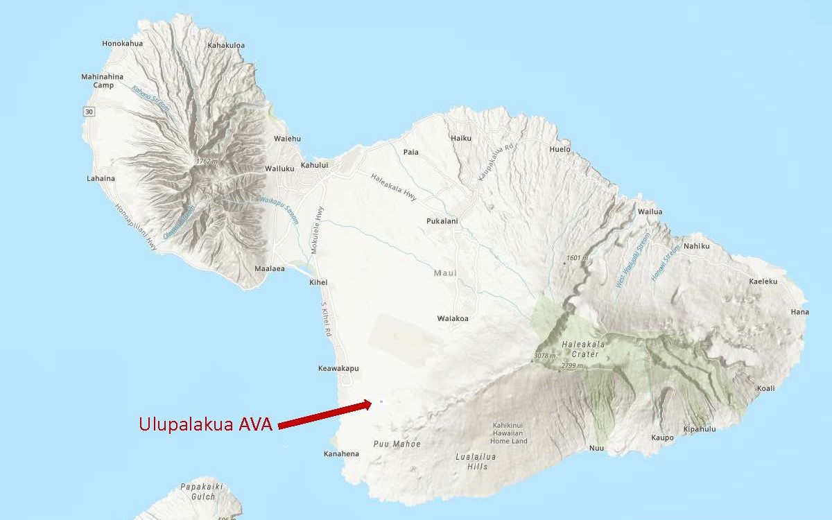
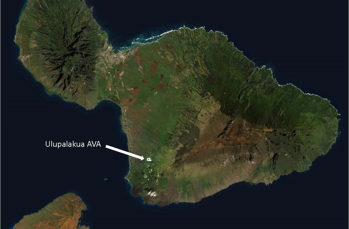
Despite being located in the tropics (the AVA itself sits at about 20°N latitude) and not being particularly well-known for grape-based viticulture or wine production, here it is: an AVA located in a small corner of the island of Maui—where grapes are grown and sent to a winery just a few miles away to be made into wine.

The Ulupalakua AVA is the first AVA to be approved in the state of Hawaii. When the new AVA comes into force on August 2, 2021, there will be a total of 257 AVAs in the United States.

Map via the TTB AVA Explorer

Map via the TTB AVA Explorer

According to the original petition for the AVA—submitted by Mark Beaman, the former winemaker at Maui Wines—the distinguishing features of area include its topography, soils, and climate, as discussed below:

Topography: The area within the Ulupalakua AVA contains a series of four distinct, southwest-facing areas of gently sloping benchlands. In contrast, the area surrounding the new AVA consists of steeper slopes, ravines, and exposed volcanic rock. The elevation of the vineyards in the AVA ranges from 1,560 feet/475 m (in the western portions) to 1,850 feet/564 m (in the east). 

Soils: The Ulupalakua AVA is located on the western slopes of Mount Haleakala—a massive shield volcano that covers more than 75% of the island of Maui. The soils of the area are predominantly composed of volcanic ash and the weathered remains of igneous volcanic rock. About 20% of the soil contains silt, loam, and clay. It is believed that they combination of soils creates an area that is fertile enough to support healthy vines, but not so fertile as to promote excessive foliage.

Map via the TTB AVA Explorer

Map via the TTB AVA Explorer

Climate: The climate within the Ulupalakua AVA reflects its tropical location and rarely drops below 50°F/10°C or goes above 85°F/29°C. The region receives quite a bit of rain—an average of 30.7 inches of rainfall a year. However, it is noted that less than two inches per month tend to fall in July and August. While humidity can certainly be seen as an issue, this period of low summer rainfall reduces the risk of mildew and rot in the days leading up to the harvest, and the mild summertime temperatures protect again sunburn and heat stress.

It is believed that viticulture began in the area in the early 1800s when an immigrant from Portugal—Don Francisco de Paula Marin—imported vines into the region and made small amounts of wine. These days, the total area within the Ulupalakua AVA comprises 70 acres; of these, 16 acres are currently under vine. Leading grape varieties include Gewurztraminer, Chenin Blanc, Viognier, Grenache, Malbec, and Syrah. There is currently one commercial vineyard— Ulupalakua Vineyards owned by Maui Wine LLC—in the region. There are no bonded wineries within the AVA, but grapes are often sent to Maui Winery (located about just a few miles away) for processing.

The name “Ulupalakua” is derived from the native language of Hawaii and may be loosely translated as “breadfruit ripened on the back.” The folklore of the area tells of how the island’s king would request that his favorite fruit—breadfruit—be brought to his home on the west coast of Maui. Harvesters would pick the unripe fruit on the island’s eastern side and carry it to the king’s house on the other side of the island. The fruit would ripen on the journey and would be totally ripe by the time they reached (the area now known as) Ulupalakua.

References/for more information:
Post authored by Jane A. Nickles…your blog administrator: jnickles@societyofwineeducators.org

Welcome to the World, Goose Gap AVA!

Map via the TTB AVA Explorer Map

Map via the TTB AVA Explorer

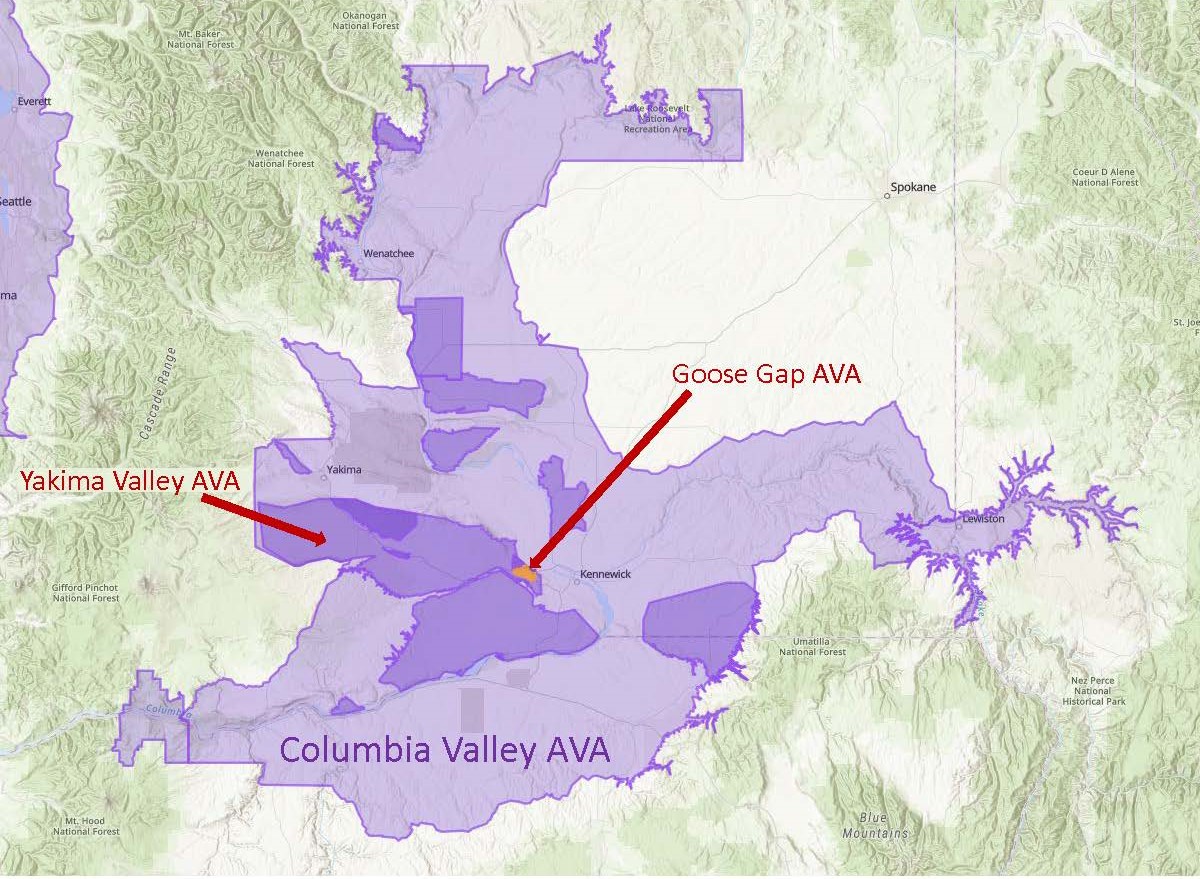
On July 1, 2021, the TTB (Alcohol and Tobacco Tax and Trade Bureau) of the United States announced a newly-approved American Viticultural Area (AVA) for Washington State: Goose Gap AVA. When this new AVA comes into force—on August 2, 2021—the total number of AVAs in the United States will be 256; of these, 19 will be located in Washington State.

Goose Gap is the third new AVA to be approved in Washington State this year; two others—The Burn of Columbia Valley and White Bluffs—were announced just last month (June 17, 2021).

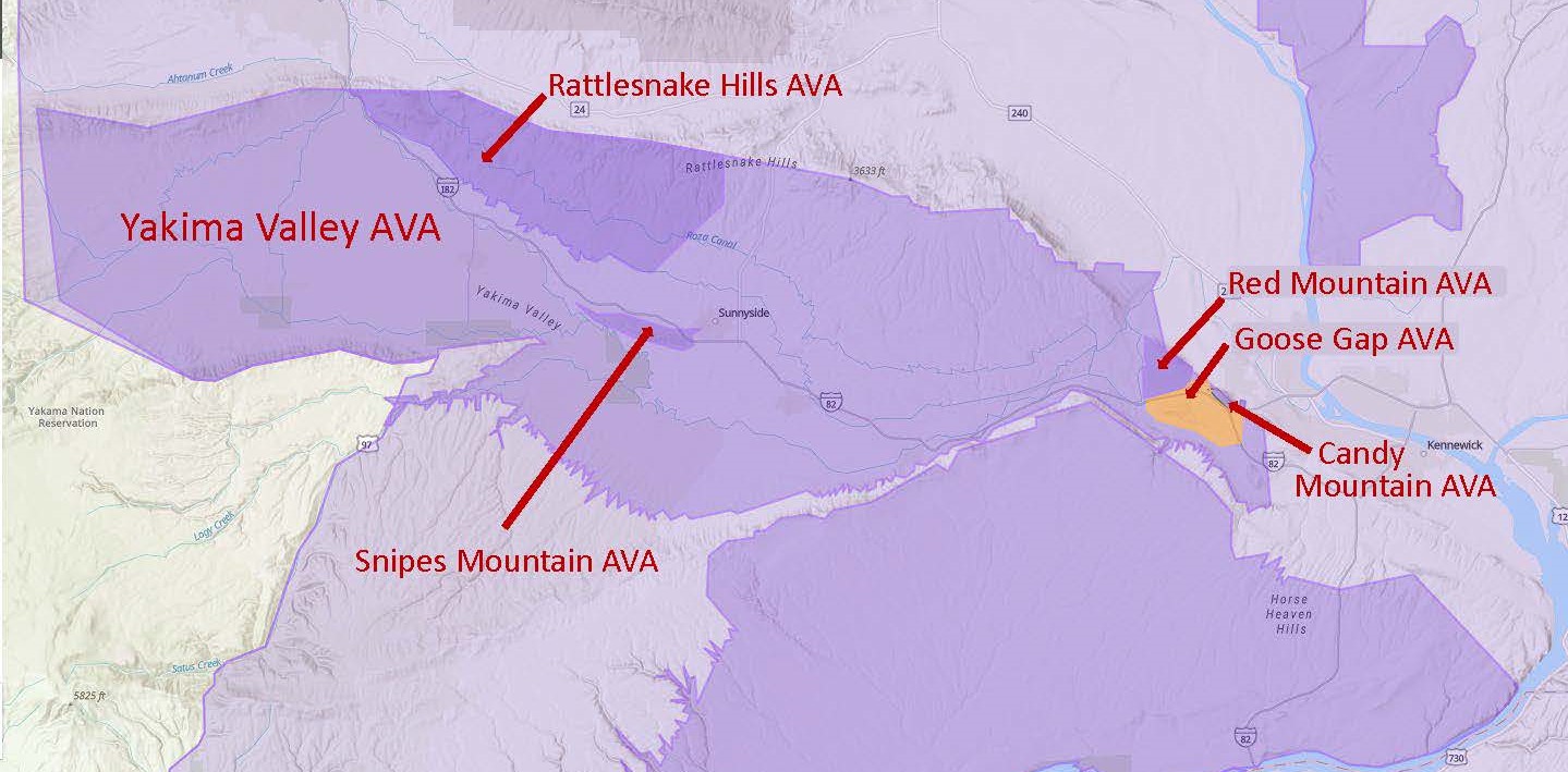
The Goose Gap AVA—a sub-region of both the Yakima Valley AVA and the larger Columbia Valley AVA—is located in Washington State’s Benton County. The triangle-shaped area is tucked between (and to the south of) the Red Mountain AVA and the tiny Candy Mountain AVA.

According to the petition—submitted by Alan Busacca, PhD, on behalf of the Goose Gap Winegrowers Association—the distinguishing features of the Goose Gap AVA include its topography and soils, as discussed below:

Topography: The Goose Gap AVA surrounds (and is mainly to the north of) a basalt ridge known as Goose Hill (sometimes referred to as Goose Mountain). The topography of the area is such that most of the south- and southwest-facing slopes in the area are too steep for successful viticulture; therefore, many of the new AVA’s vineyards are planted on north- and northeast-facing slopes. As a result, the vines in the Goose Gap AVA receive less solar radiation than those planted on the south- and southwest-facing slopes of the nearby appellations, leading to longer growing periods and later harvest dates for the vines of the Goose Gap.

The elevation within the Goose Gap AVA ranges from 577 feet (176 m) above sea level (at the southern boundary) to 1,339 feet (408 m) atop of Goose Hill.

Map via the TTB AVA Explorer

Map via the TTB AVA Explorer

Soils: Many of the soils in the area—covering about 65% of the appellation—consist of wind-blown loess over layered silt and fine-textured sand. In many spots, this topsoil extends for six feet with no hardpan or other root impediments. Other areas of the appellation are also covered by loess, but with varying depths of loess as well as vary amounts of fractured basalt and flood sediment atop the underlying basalt bedrock. The soils of the Goose Gap AVA contain a higher overall percentage of loess, silt, and sand than the soils of the surrounding areas.

The area within the Goose Gap AVA covers a total of 8,129 acres; of these, 1,800 acres (728 ha) are planted to vines. The region is currently home to two commercial vineyards—including the 1,700-acre (688 ha) Goose Ridge Estate Vineyard—and one bonded winery (Goose Ridge Winery). Commercial vineyards specializing in Cabernet Sauvignon and Merlot have been planted in the area since 1998. Other forms of agriculture—including apple orchards, cherry orchards, alfalfa fields, and sheep grazing are traditional to the area.

About that name: The new AVA is located along the migratory path of several flocks of wild geese. The local use of the term “Goose Gap” as well as “Goose Hill” can be traced back to the early 1900s. The area bears the tales of many legendary goose hunts from the 1800s; First Peoples are known to have hunted geese in the area as well.

References/for more information:
Post authored by Jane A. Nickles…your blog administrator: jnickles@societyofwineeducators.org

Welcome to the World, Palos Verdes Peninsula AVA!

Map via the TTB AVA Explorer Map

Map via the TTB AVA Explorer Map

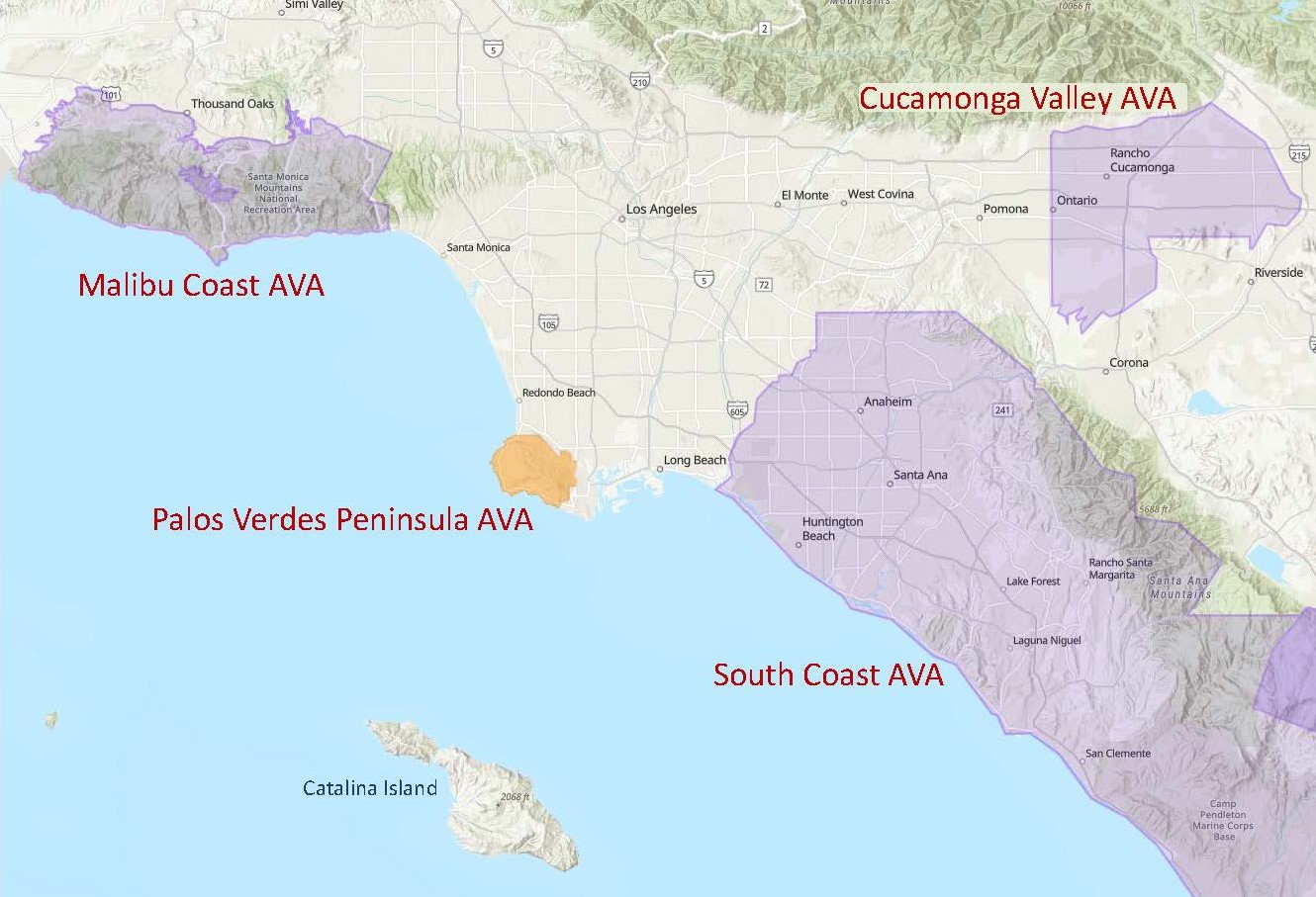
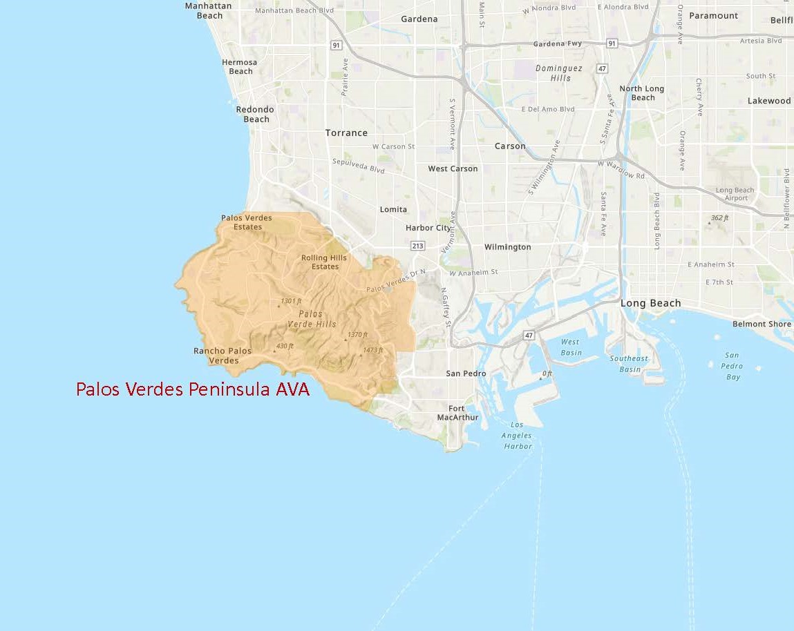
On June 17, 2021, the TTB (Alcohol and Tobacco Tax and Trade Bureau) of the United States approved the Palos Verdes Peninsula AVA. When this new AVA comes into force—on July 19, 2021—the total number of AVAs in the United States will be 255, of which 142 will be in California.

The Palos Verdes Peninsula area—located in the southwestern corner of Los Angeles County—hugs the Pacific Ocean coastline about 25 miles west of downtown Los Angeles. The region includes the cities of Palos Verdes Estates, Rolling Hills Estates, Rancho Palos Verdes, and Rolling Hills, California. The area is highly regarded for its sweeping views of the ocean and the Los Angeles city skyline, gated communities, and high-dollar homes. However, the area has a long history of agriculture—including some viticulture—and wine continues to be produced in the area.

According to the original petition—spearheaded by James York of Catalina View Wines and submitted on behalf of a group of Palos Verdes Peninsula winegrowers—the area’s distinguishing characteristics include its topography, soils, and climate. These are discussed below:

Topography: The area within the Palos Verdes Peninsula AVA consists of low rolling hills (technically part of the Coast Range) situated between the Los Angeles Basin and the Pacific Ocean. Elevations range from sea level (on the region’s western and southern edges) to 1,460 feet/445 m above sea level at San Pedro Hill. Many of the region’s vineyards are planted on moderate south- or southeast-facing slopes. 

Map via the TTB AVA Explorer Map

Map via the TTB AVA Explorer Map

Soils: The soils of the region include Altamont Clay Adobe, Altamont Clay Loam, and Diablo Clay Adobe. These soils are composed primarily of fine-grained sandstone, weathered shale, silt, and calcareous clay.  These soils retain allow for moisture retention in dry weather while allowing for drainage during rainy times.

Climate: Like many areas of Southern California, the Palos Verdes Peninsula AVA has an overall Mediterranean Climate coupled with the coastal influence of the nearby Pacific Ocean. The area typically experiences warm, dry summers (temperatures rarely exceed 84°F/29°C) and mild winters with limited rainfall.

The Palos Verdes Peninsula AVA includes a total of 15,900 acres; of these, just over 7 acres are currently planted to vines. Two producing wineries—Catalina View Wines and La Caze Family Vineyard—are located within the region. The leading grape varieties include Pinot Noir, Chardonnay, Cabernet Sauvignon, and Merlot

Welcome to the world, Palos Verdes Peninsula AVA!

References/for more information:
Post authored by Jane A. Nickles…your blog administrator: jnickles@societyofwineeducators.org

Welcome to the World: The Burn of Columbia Valley AVA!

Map via the TTB AVA Explorer Map

Map via the TTB AVA Explorer Map

On June 17, 2021, the TTB (Alcohol and Tobacco Tax and Trade Bureau) of the United States approved two new American Viticultural Areas (AVAs): the White Bluffs AVA and the Burn of Columbia Valley AVA. When these new AVAs come into force—on July 19, 2021—the total number of AVAs in Washington State will be 18.

This article will focus on the Burn of Columbia Valley AVA. Click here for an article focusing on the While Bluffs AVA.

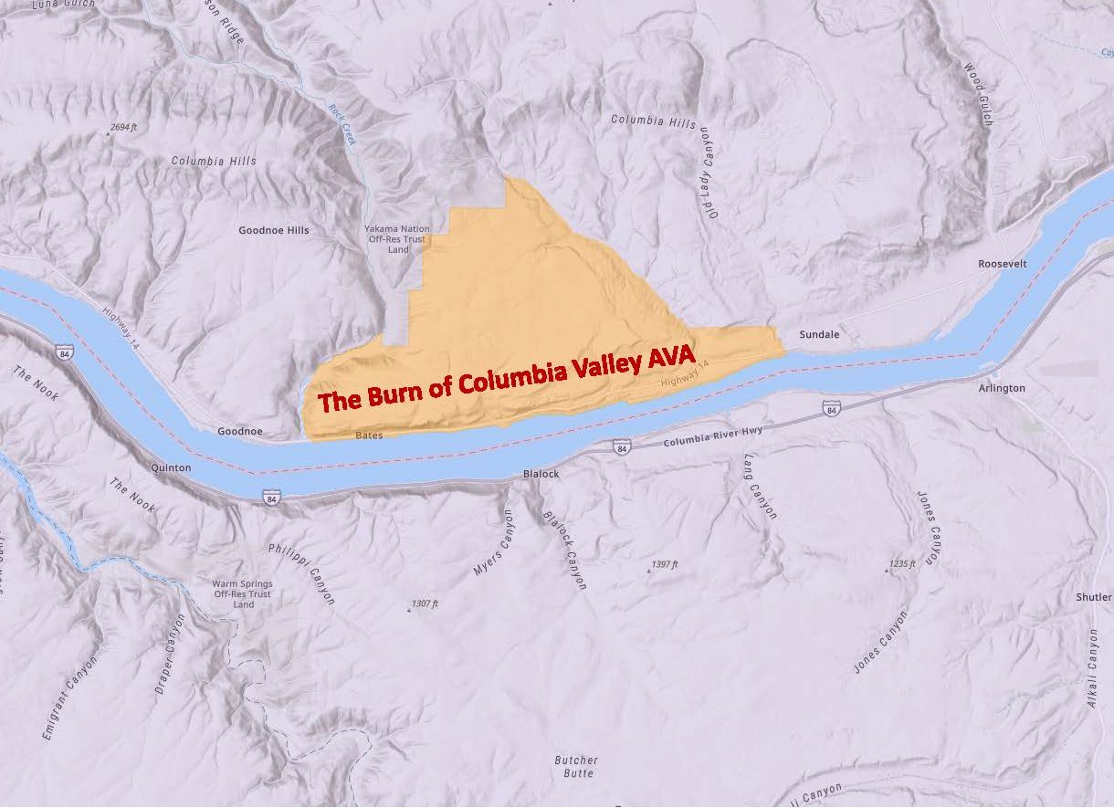
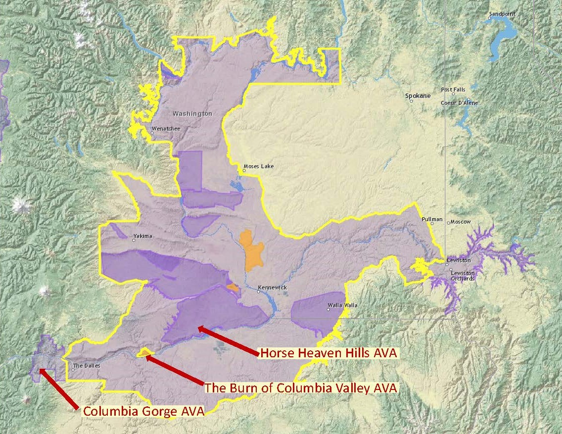
The Burn of Columbia Valley AVA (a sub-region of the Columbia Valley AVA) is located in the southwest corner of the Columbia Valley AVA, along a stretch of benchland on the north bank of the Columbia River. It is situated between the Horse Heaven Hills AVA (to its east) and the Columbia Gorge AVA (to its west). Its location along the Columbia River places it adjacent to the border between Washington State and Oregon—although it lies 100% in Washington State.

The petition to establish The Burn of Columbia Valley AVA (originally slated as “The Burn”) was submitted by Kevin Corliss of Ste. Michelle Wine Estates, Joan Davenport (Professor of Soil Sciences at Washington State University), and John Derrick of Mercer Ranches. According to the petition, the area’s distinguishing features include its topography, climate, and soils—as discussed below.

Topography: The area within the new AVA is situated on a moderately-elevated, gently sloping benchland above the Columbia River. The (generally) southeast-facing slope averages just over 7% grade.

Map via the TTB AVA Explorer Map

Map via the TTB AVA Explorer Map

Climate: The area is considered (overall) one of the warmer regions of the Columbia Valley. However, due to the persistent winds from the Columbia Gorge, the heat (as measured by “degree days”) accumulates much more slowly than in the surrounding areas. As a result, the growing season is extended—the grapes in this area are often among the last to be harvested in the state. This lengthy growing season allows for deep flavor development and excellent acid retention in the grapes.

Soils: The soils within the new AVA—dominated by Walla Walla silt loam—are, in many aspects, similar to those of the surrounding areas. However, the soils within The Burn contain a higher proportion of organic matter and lower levels of sand/sandy loam—and, as a result, the soils of The Burn have higher water- and nutrient-retention capacity. This means that the region has a lower need for supplemental irrigation, a lower need for the use of supplemental vine nutrients, and a reduced risk of winter vine injury as compared to the surrounding areas.

The triangle-shaped Burn of Columbia Valley AVA covers a total of 16,870 acres. Of these, approximately 1,500 acres/607 ha have been planted to vines. The region contains two commercial vineyards and no bonded wineries (as of 2021). This is a young growing area; while vines have been planted in the area since 2002, the majority of the vines have been planted since 2015. Cabernet Sauvignon is the leading variety, followed by Syrah, Malbec, Chardonnay, and Sangiovese.

About that name: there is no easy consensus on where the name—The Burn—originated, although there is plenty of evidence that it has been used in reference to the area for generations. The Burn might refer to a local legend that tells of early settlers who set fire to the benchland every fall in order to rejuvenate the native grasses and provide for their horses in the springtime. It could also be based on the Gaelic- German- and English-inspired use of the term burn (as in Bannockburn)—or born (as in Padderborn) or bourne (as in Melbourne)—to refer to a stream or a river.

Welcome to the world: The Burn of Columbia Valley AVA!

P.S. The TTB has also announced a new AVA in California—Palos Verdes Peninsula—to be effective on July 19, 2021. Click here for more details. 

References/for more information:
 Post authored by Jane A. Nickles…your blog administrator: jnickles@societyofwineeducators.org

Washington State Welcomes Two New AVAs! (focus on: the White Bluffs AVA)

Map via the TTB AVA Explorer Map

Map via the TTB AVA Explorer Map

On June 17, 2021, the TTB (Alcohol and Tobacco Tax and Trade Bureau) of the United States approved two new American Viticultural Areas (AVAs): the White Bluffs AVA and the Burn of Columbia Valley AVA. When these new AVAs come into force—on July 19, 2021—the total number of AVAs in Washington State will be 18.

This article will focus on the White Bluffs AVA; click here for an article focusing on the Burn of Columbia Valley AVA.

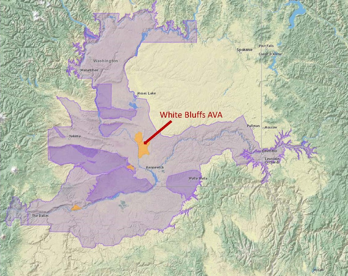
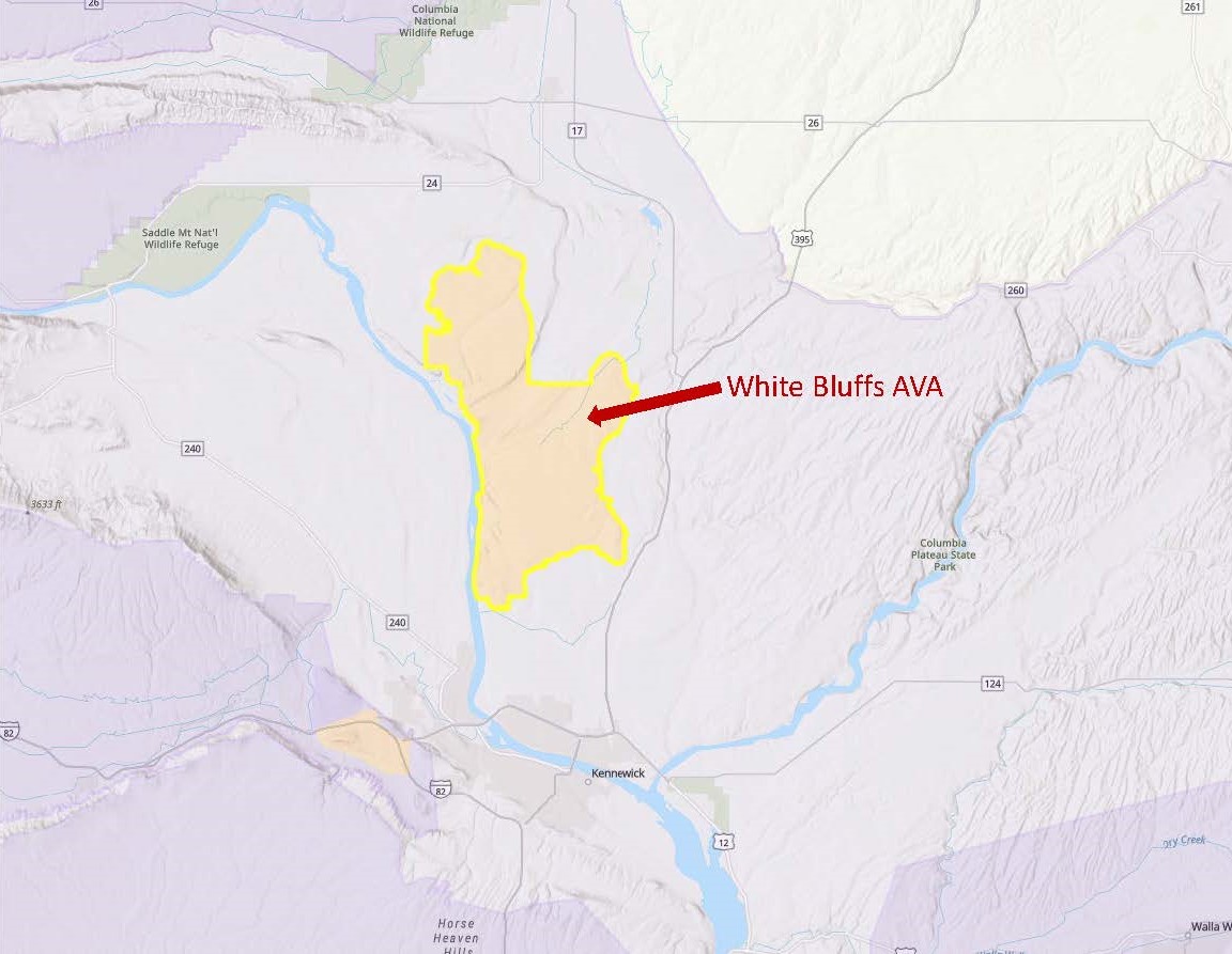
The White Bluffs AVA—named for a steep escarpment located along the eastern shore of the Columbia River—is located with Franklin County, about 10 miles/16 km north of the town of Kennewick. The White Bluffs AVA is a sub-region of the much larger Columbia Valley AVA.

The defining characteristics of the White Bluffs AVA include the area’s topography, soils, and climate. These features—as noted by Dr. Kevin Pogue, Professor of Geology at Whitman College and the author of the original petition—are discussed below.

Topography: The White Bluffs AVA sits atop an elevated plateau, as much as 200 feet/61 meters above the surrounding area (known as the Pasco Basin). As a result, the overall elevation of the region varies between 800 feet/244 meters and 1,000 feet/305 meters above sea level. The plateau is divided by the Ringold Coulee and the Koontz Coulee into two relatively flat areas known as the Columbia Flat and the Owens Flat. In addition, the southern edge of the appellation includes a portion of the south-facing slopes of the namesake White Bluffs. 

Map via the TTB Explorer Map

Map via the TTB AVA Explorer Map

Soils: The topsoil of the area—windblown silt (loess) and alluvial deposits from the Missoula floods—is quite similar to the soils in the surrounding areas. However, what lies beneath—a layer of ancient lakebed sediment with a whitish appearance topped by a layer of caliche (calcium carbonate)—is unique. This layer—known as the Ringold Formation—also contains enough clay so that the soil retains different proportions of water and minerals (as compared to those of the surrounding areas). In addition, the Ringold Formation is deep enough so that the roots of the vines planted in the White Bluffs AVA—unlike the vines in much of the rest of the Columbia Valley AVA—do not ever reach the basalt bedrock. 

Climate: Due to the added elevation, the area within the White Bluffs AVA is protected from the cold air on the surrounding valley floor. This makes for a slightly warmer temperature and longer growing season, as compared with the surrounding area. Vines have been planted in the area since 1972 and have never experienced a freeze during the growing season.

The White Bluffs AVA covers a total of 93,738 total acres (146 square miles), with 1,127 acres/456 ha planted to vines. Currently, there are nine commercial vineyards and one bonded winery—Claar Cellars—located within the boundaries of the appellation. The leading grape varieties include Cabernet Sauvignon, Merlot, Syrah, Riesling, and Sauvignon Blanc.

Welcome to the world, White Bluffs AVA!

P.S. The TTB has also announced a new AVA in California—Palos Verdes Peninsula—to be effective on July 19, 2021. Click here for more details. 

References/for more information:
Post authored by Jane A. Nickles…your blog administrator: jnickles@societyofwineeducators.org

Dispatch from Amboise (and the Touraine AOC)

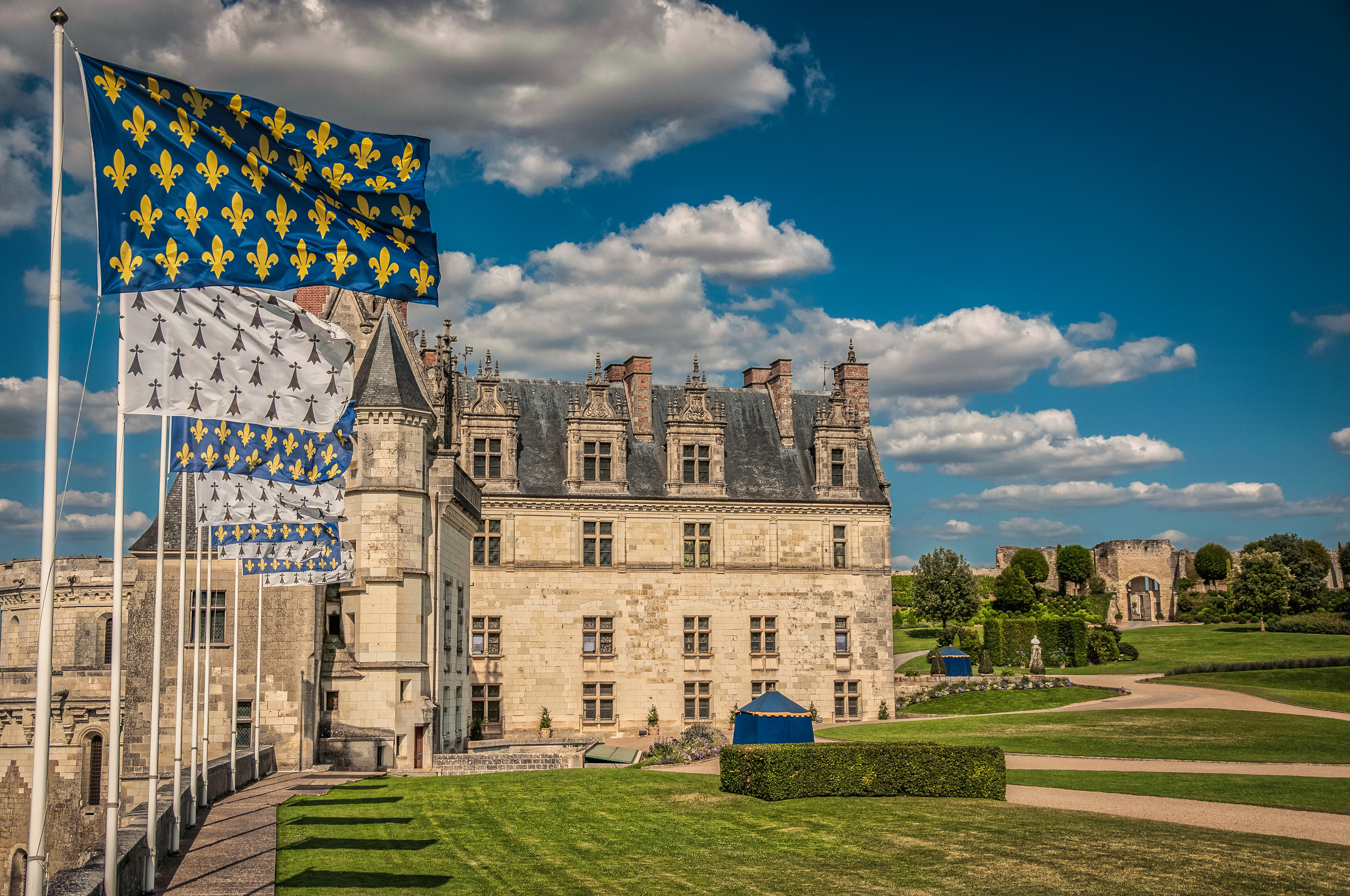
 Château d'Amboise

Château d’Amboise

Amboise is a tiny French town situated on the banks of Loire River (about 17 miles/27 km east of Tours) and just a short drive (11 miles/18 km) away from the awe-inspiring Château de Chenonceau.

Despite its small stature, Amboise has a lot going for it. For one, it is home to the Château du Clos Lucé, originally built by the Hugues d’Amboise (nobles of the House of Amboise) in 1471. The Château du Clos Lucé has had several famous occupants, including Leonardo da Vinci who resided in the palace for the last few years of his life. Upon his death in 1519, the great artist was laid to rest in the nearby Chapel of St Florentin. When the Chapel of St. Florentin was razed at the end of the 18th century, Leonardo’s tomb was moved to the grounds of the Château d’Amboise. (At least that is what most people believe; there are some skeptics.)

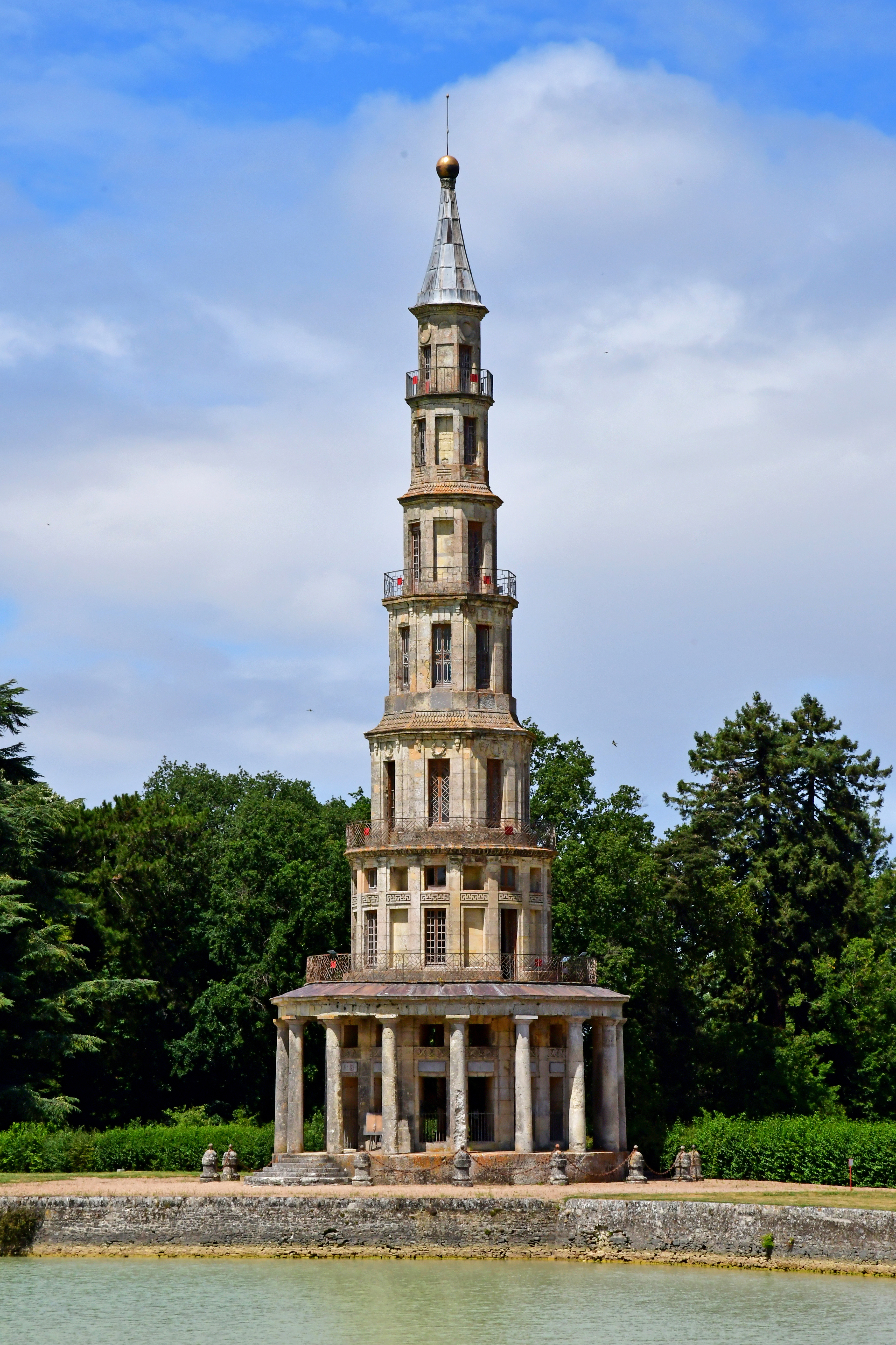
Grounds of the Château de Chanteloup

Grounds of the Château de Chanteloup

Amboise is also home to what might be the only pagoda ever built on the banks of the Loire—the pagoda of the Château de Chanteloup—and the Parc des Mini-Chateauxa theme park where you can walk among 40 miniature renditions of the famous castles, gardens, and villas of the Loire.

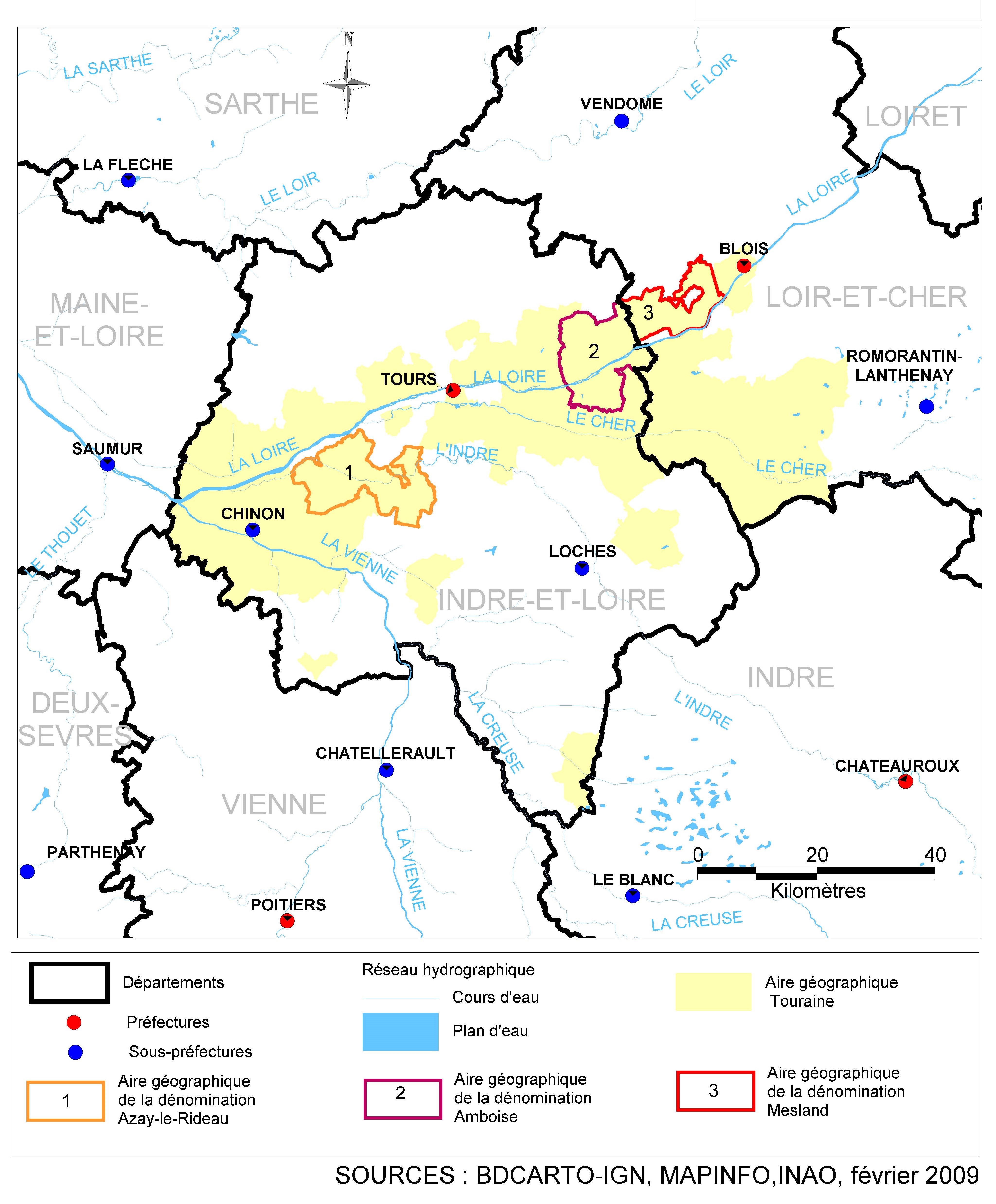
Amboise is also known for its wine; much of which is bottled under the Touraine-Amboise appellation. Amboise is currently one of the five sub-zones/geographic indications that are allowed to append their name to the Touraine AOC designation—as long as the mandated, specific standards are followed. There are rumors afloat that Amboise will (someday soon) apply for a separate AOC, however, this has not yet approached the national level.

There have, nevertheless, been some recent changes to the rules and regulations concerning the wines of the Touraine-Amboise AOC. These include revisions to the allowed grape varieties, viticultural practices, and character of the finished wine. The most substantive of these changes concern the allowed grape varieties, as follows:

  • Varietal composition of red wines: Must be 100% Côt. They take Côt seriously in Amboise and consider it a specific (and historical) local variation of Malbec. Though previously allowed, Cabernet Sauvignon, Cabernet Franc, and Gamay are no longer permitted to be used in the red wines of the Touraine-Amboise AOC.
  • Varietal composition of rosé wines: May be produced using any proportion of Côt and/or Gamay. Though previously allowed, Cabernet Sauvignon and Cabernet Franc are no longer permitted to be used in the rosé wines of the Touraine-Amboise AOC.
Map of the Touraine AOC (showing the Amboise subzone) via the INAO

Map of the Touraine AOC (showing the Amboise subzone) via the INAO

Touraine-Amboise AOC white wines are required to be 100% Chenin Blanc (this standard has not changed).

Note: For the serious wine students in our audience—the other four subzones of the Touraine AOC are as follows: Mesland, Azay-le-Rideau, Oisly, and Chenonceaux.

References/for more information:
Post authored by Jane A. Nickles…your blog administrator: jnickles@societyofwineeducators.org

Dispatch from Bardolino

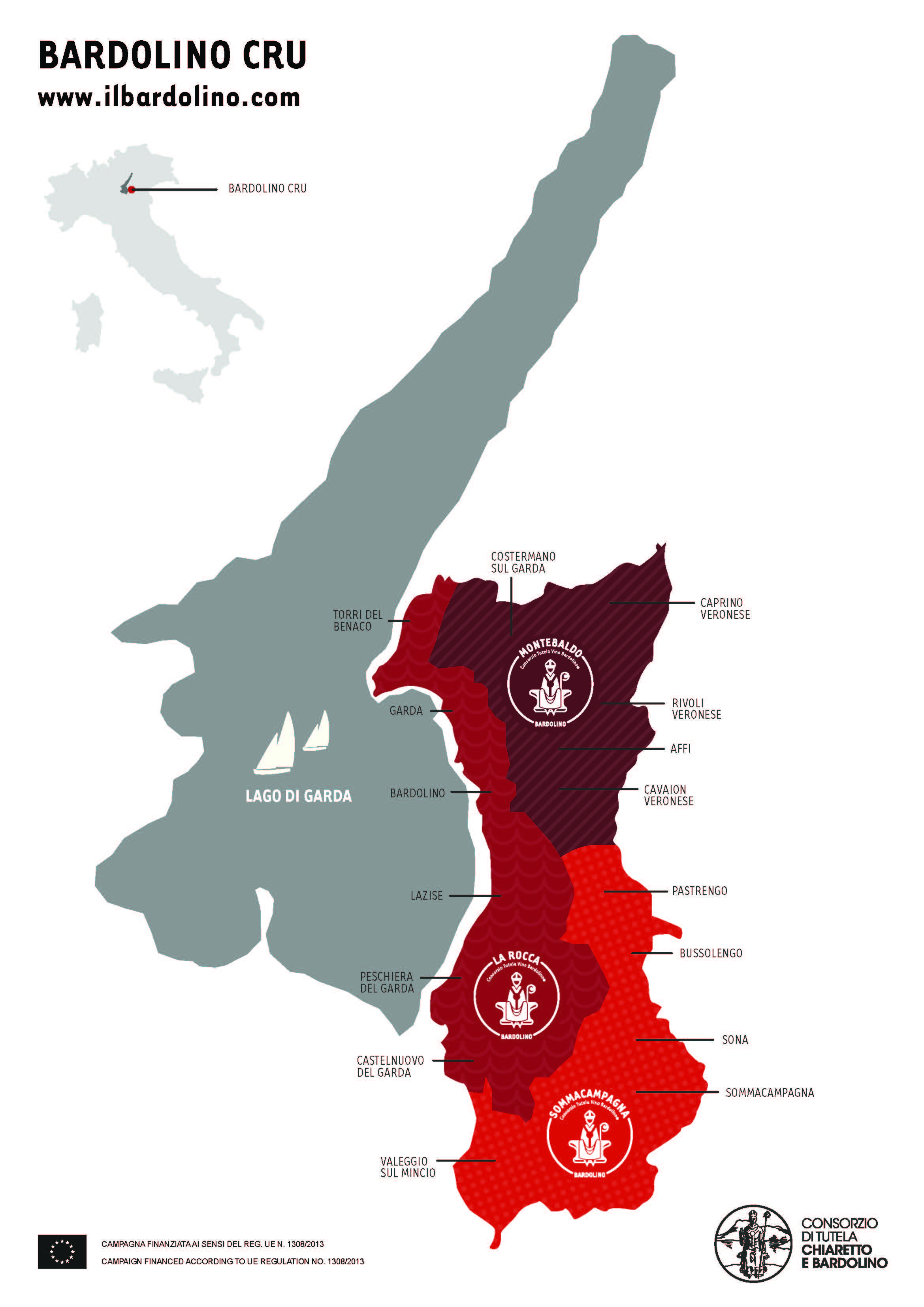
Map via: https://consorziobardolino.it/

Map via: https://consorziobardolino.it/

Heads up, wine students of the world! In the April 12, 2021 edition of the Gazzetta Ufficiale della Repubblica Italiana (Official Journal of Italy), it was announced that there have been a few changes made in the rules and regulations of the Bardolino DOC. Bardolino—located on the banks of Lake Garde in Italy’s Veneto—is well-known for its lively red and rosé (chiaretto) wines based on the Corvina grape variety.

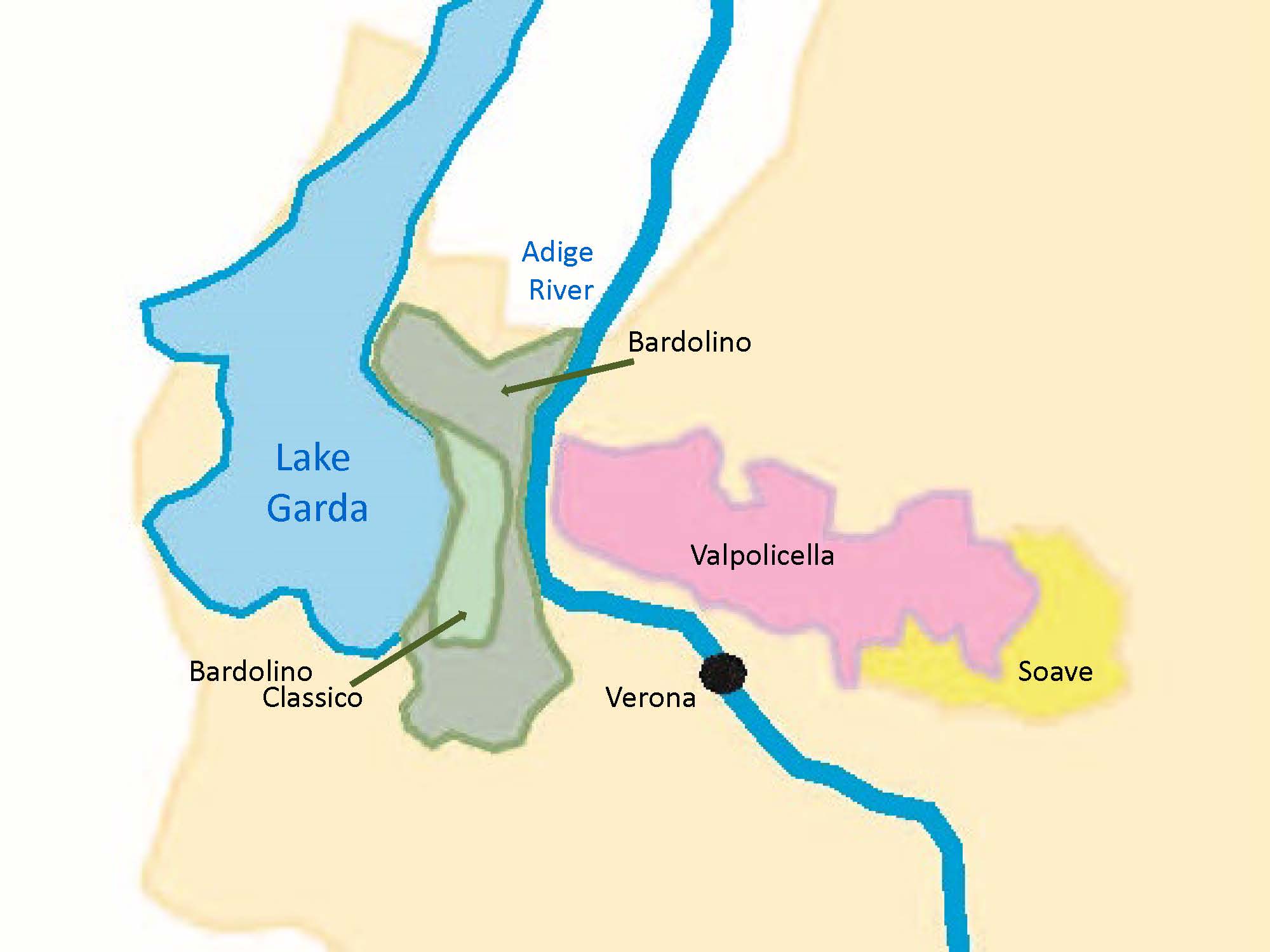
The main update involves three new subzones of the Bardolino appellation. These new regions—La Rocca, Montebaldo, and Sommacampagna—have been approved for use upon the release of the region’s 2018 vintage. The previously existing Bardolino Classico subzone will remain in place and is unaffected by the changes.

According to the website of the Consorzio di Tutela Chiaretto e del Bardolino, the newly approved subzones represent a historical view of region. These areas have been recognized since the 19th century, when they were documented by a local scholar known as Giovanni Battista Perez. These subzones were not, however, written into the original specification of the Bardolino DOC (first established in 1968).

Here is some information about each of the new subzones:

Bardolino-La Rocca takes up the entirety of the area adjacent to Lake Garda, and represents the ancient district of Bardolino, which has ties to the Roman Empire and was mentioned in the 12th century as a free commune. In the 1200s, the area was expanded and fortified under the “protection” of the Scaligeri of Verona; after the fall of the Scaligeri the area become part of the Republic of Venice.

Map indicating the (previously existing) Bardolino Classico subregion

Map indicating the (previously existing) Bardolino Classico subregion

Bardolino-Montebaldo encompasses the area of the eastern foothills of Monte Baldo Mountain Range. The Monte Baldo Range—part of the larger Garda Mountains—is basically a mid-level ridge running parallel to (and east of) to Lake Garda for about 25 miles (40 km).  The area around the Monte Baldo Mountains is often called “the Garden of Europe” due to the incredible plant biodiversity (and copious beautiful wildflowers) of the area.

Bardolino-Sommacampagna accounts for the rolling hills in the southern reaches of the district.  The area takes its name from the commune of Sommacampagna, located in the southeast of the zone.

Note: As with all such updates, this change will need to wind its way through EU approval; however, as the Italian government has granted their approval, we should begin to see the new subzones appear on wine labels with the release of the wines of the 2018 vintage.

References/for more information:
Post authored by Jane A. Nickles…your blog administrator: jnickles@societyofwineeducators.org